
Views#
MapX uses a two-level data management system based on sources and views.
A source is the underlying spatial dataset stored in the MapX database. A view is the cartographic representation of a source, defining how the data is displayed and interacted with on the map. In practice, however, views can go beyond simple map rendering and may include custom interfaces, external data connections, or communication-oriented layouts.
The main types of views available in MapX are:
- Vector tile views
Vector tile views are used to display spatial data published in the MapX database.
- Raster views
Raster views are based on external data services, as MapX does not store raster data directly in its database.
- Custom coded views
Custom coded views are fully customizable views that can be used to display data from external sources or implement advanced interactive features, such as drop-down lists, sliders, charts, or other custom controls. Creating this type of view requires advanced web development skills.
- Story maps
Story maps are communication products that combine spatial data with other types of content, such as text, images, charts, and videos.
- Local GeoJSON views
Local GeoJSON views allow users to visualize vector data without uploading it to the MapX database. The data is temporarily stored in the user’s browser and is not persisted in the MapX database.
The different view types are identifiable in MapX by the color of the circle displayed to the left of their title:
green: vector
purple: raster
blue: story map
red: custom code
orange: local GeoJSON

Types of view#
In the MapX interface, a view is presented as follows in the data catalog:
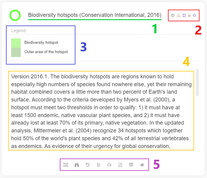
Anatomy of a View#
view title
badges associated with the view
legend of the style applied to the data
abstract providing users with key information to understand the data
tools associated with the view
To display the data associated with a view on the map, simply click the button next to the view’s title. Multiple views can be activated at the same time. When this is the case, the order in which views are displayed in the map is defined by the position of the views in the catalog. It is possible to modify the order by grabbing the view with the pointer and dragging it in the catalog to change its position.